IDENTIFYING AND MONITORING OF FORAGE FISH SPAWNING BEACHES IN BRITISH COLUMBIA’S SALISH SEA FOR CONSERVATION OF FORAGE FISH
Haley Tomlin, Chrissy Schellenberg, Jacklyn B. Barrs, Alanna J.S. Vivani, and Pam Shaw | June 24, 2021
Abstract
Pacific sand lance (Ammodytes personatus) and surf smelt (Hypomesus pretiosus) are ecologically important forage fish in the marine food webs within the Salish Sea, including British Columbia (BC). Although important, little information exists around the spatiotemporal distribution of these fishes’ beach spawning habitat in the BC Salish Sea. In 2017, the Mount Arrowsmith Biosphere Region Research Institute initiated spawning beach surveys within the Mount Arrowsmith Biosphere Region (MABR). Surveys have geographically expanded along the eastern Vancouver Island coastline between Bowser and Cowichan Bay, BC, including Gabriola Island and Thetis Island. Pacific sand lance embryos have been detected at 17 beaches, with six beaches located within the MABR. Pacific sand lance spawning events have been detected between November and mid-February, with the bulk of embryos detected in November and December. To date, surf smelt embryos have not been detected at the 56 different beaches. These data begin to fill existing data gaps surrounding Pacific sand lance and surf smelt in BC. Furthermore, longer-term data submissions to the Strait of Georgia Data Centre, an open-access database, will provide the necessary data needed to advocate for improved regulatory protections for these ecologically important fish and their spawning habitat.
Introduction
Forage fish
In marine systems, small pelagic schooling fish (e.g., Pacific sand lance, surf smelt, and Pacific herring) characterize forage fish. Forage fish species are an important food source for a variety of top predators including large pelagic fish, demersal fish, marine mammals, and birds (Meyer 1997; Robards et al. 1999, Harvey et al. 2010). Most of the energy transferred within these marine ecosystems occurs through a small number of key forage fish species that bridge the transfer of energy from the primary and secondary producers (e.g., plankton) to the top predators situated in the higher trophic levels (Cury et al. 2000). Thus, forage fish play a crucial role within marine food webs, including the waters of the Salish Sea.
Forage fish tend to experience natural fluctuations in their populations due to natural cycles that occur in the marine environment; some years they are in much greater abundance than others (Essington et al. 2015). However, anthropogenic activities, such as overfishing and habitat degradation, can exacerbate these natural fluctuations (Essington et al. 2015). Any variations in forage fish productivity and biomass can induce widespread and unanticipated ecological impacts, altering the function and structure of marine ecosystems (Engelhard et al. 2014; Essington et al. 2015; Siple et al. 2019).
Pacific sand lance
Pacific sand lance (Ammodytes personatus; Orr et al. 2015) are energy rich and are an integral part of the marine food web (Van Pelt et al. 1997; Anthony et al. 2000; Ostrand et al. 2005; Selleck et al. 2015). They are a recognized prey source for 45 species of commercial fish, including Pacific salmon, 40 seabird species, and 12 marine mammals (Sisson and Baker 2017). Pacific sand lance are found within nearshore shallow environments of the northeastern Pacific, along the west coast of Canada and the United States (Hiss 1985; Quinn 1999; Robards and Piatt 1999). They are not thought to perform seasonal migrations; instead, they are associated with sandy substrates year-round (Hiss 1985). Pacific sand lance are considered to be an epi-benthic species between spring and fall, foraging in the pelagic water columns for zooplankton and burrowing in suitable sediments of medium to coarse sand (0.25–2 mm) to rest or evade predators (Quinn 1999; Haynes and Robinson 2011; Robinson et al. 2013). In the winter during prey scarcity, they are thought to aestivate by burrowing in the same suitable sediments used to rest and evade predators (Quinn 1999). However, recent studies indicate that Pacific sand lance depart their subtidal burying habitats for short periods to spawn on the upper areas of intertidal beaches that contain medium-sized sand sediments ranging from 0.25 to 0.5 mm, but will also spawn on coarse sand and fine pebble sediments (1–7 mm) (Thuringer 2004; Penttila 2007; Robinson et al. 2013; Selleck et al. 2015).
Surf smelt
Surf smelt (Hypomesus pretiosus) are considered an important food source for a wide variety of marine predators, including piscivorous birds, seals, and marine mammals (Penttila 2001; Therriault and Hay 2003; Therriault et al. 2009). Surf smelt occupy the northeast Pacific temperate, coastal waters, ranging from southern Alaska to California (Middaugh et al. 1987; Therriault and Hay 2003; Lee and Levings 2007). Adult and juvenile surf smelt are considered a nearshore pelagic fish because of limited detection of juvenile surf smelt in ichthyoplankton surveys (Therriault and Hay 2003). They are obligate beach spawners. Surf smelt spawn during high tides on the upper intertidal sediments and prefer to spawn in a substrate of coarse sand to fine pebble mix ranging from 1 to 7 mm in diameter (Penttila 2001, 2007). They appear to tolerate highly variable salinity regimes found on and around their spawning beaches, with shade from riparian vegetation acting as an important means of temperature regulation during summer spawning (Fisheries and Oceans Canada (DFO) 2002; Penttila 2001, 2007; Quinn et al. 2012).
Data gaps
Despite the ecological importance of Pacific sand lance and surf smelt in the marine ecosystems, our understanding of the basic biology (e.g., spawning patterns) and population status are limited (Quinn et al. 2012; Selleck et al. 2015). In British Columbia (BC), there have been no government systematic or nonsystematic intertidal surveys for forage fish spawning habitat or spawning events for either species of interest (Levings and Jamieson 2001; DFO 2002; Therriault and Hay 2003). Present knowledge of certain surf smelt spawning events and locations in BC was obtained from surf smelt harvesting at spawning beaches in Burrard Inlet (DFO 2002). Some surveys have occurred over time to determine where and when spawning occurs, but are independent and not continuous (Boldt et al. 2012). Both Archipelago Marine Services and Sea Watch Society have conducted intertidal studies for both surf smelt and Pacific sand lance, while surveys for Pacific sand lance subtidal burrowing habitat have been undertaken by Fisheries and Oceans Canada (DFO) (Thuringer 2004; Robinson 2019; Strait of Georgia Data Centre (SGDC) 2020). None of the studies have been long-term, therefore no trends have been identified (Boldt et al. 2012).
Knowledge regarding the spawning windows and preferential site characteristics for surf smelt and Pacific sand lance spawning in BC has been adopted from the work completed in Washington State. The Washington Department of Fish and Wildlife (WDFW) began monitoring forage fish species, including their ecology, genetics, distribution, abundance, and the influence of anthropogenic activities in 1971 (Lowry 2012). Systematic surveys of Pacific sand lance and surf smelt spawning habitat began in 1989; therefore, they have an extensive database identifying where and when Pacific sand lance and surf smelt have been spawning throughout Puget Sound (Moulton and Penttila 2006). WDFW is now able to use this database to protect intertidal regions that had Pacific sand lance and surf smelt spawning activity recorded (Moulton and Penttila 2006). In Washington State, Pacific sand lance spawn from November through mid-February, while surf smelt have been found to spawn year-round, with the summer spawning population being most abundant (Penttila 2007; Quinn et al. 2012).
There is still limited knowledge of spatiotemporal spawning patterns for surf smelt and Pacific sand lance off the coast of BC due to limited and inconsistent surveys. Initial findings in BC indicate that Pacific sand lance spawn in the late winter, while surf smelt spawn in the spring and summer months (Therriault and Hay 2003; Haynes and Robinson 2011). For BC to accurately estimate and determine Pacific sand lance and surf smelt spawning activity, habitat distribution, and population trends, a greater extent of long-term data must be collected.
Policy and management
Given the limited knowledge in BC surrounding forage fish beach spawning sites, it is possible that some of the provisions designed to protect these fish and their habitat under the Fisheries Act could be inadequate (e.g., timing windows). In addition, permitted shoreline modifications could result in unforeseen consequences to spawning habitat (e.g., loss of suitable spawning material). Ultimately, data collected could identify potential restoration areas and influence changes to regulatory protection measures designed to protect intertidal fish habitat.
The monitoring project goals are (i) to contribute to the knowledge surrounding spawning seasons and beaches of surf smelt and Pacific sand lance within BC, (ii) to use this knowledge to help modify and improve inadequate protection measures for these fish and their habitat, and (iii) to contribute the data collected to an open-access database so that it can be accessed by researchers, local governments, and community members involved in development and conservation planning.
Methods
Site locations
The Mount Arrowsmith Biosphere Region Research Institute (MABRRI) began sampling in December 2017 and has been sampling year-round since the project’s inception. To begin, sampling was focused in the Mount Arrowsmith Biosphere Region (MABR), specifically the Parksville Qualicum Beach Wildlife Management Area. The MABR was a small, focus area that the project could be initiated in, with the intention of ultimately expanding to cover the mid-Vancouver Island region, including the surrounding Gulf Islands. As biosphere reserves are often advertised as “living laboratories”, they provide sites for researchers and community groups to identify, promote, and seek conservation for biodiversity (Reed and Massie 2013). Therefore, the area was an appropriate location to launch the project.
In 2018, MABRRI began training citizen science groups to sample for Pacific sand lance and surf smelt embryos. By expanding sampling efforts through both MABRRI and the multiple citizen science groups, a greater extent of the coastline has been simultaneously and continuously sampled throughout the year. The sample locations are subdivided into regions to easily distribute the sites to citizen scientists. The regions are named after the municipality they are closest to (e.g., Nanaimo, Qualicum Beach, Gabriola Island, etc.). Currently, there are 56 beaches that are monitored throughout 11 different regions between Cowichan Bay and Bowser on Vancouver Island, including sites on Gabriola Island and Thetis Island (Fig. 1). Beaches are defined as continuous stretches of coastline with similar or only moderate variation in site characteristics. Depending on its length, a beach may have more than one beach station, or site that samples are collected from. A beach station represents a 300 m extent of coast; therefore, a beach that has 600 m of suitable spawning sediments would have two beach stations. The number of sites that are sampled each month varies based on the site characteristics and personnel availability. As a result of the inclusion of citizen scientists, the project has geographically expanded up and down the Vancouver Island coastline, increasing the number of beaches and beach stations each year, resulting in greater amounts of data collected. Although sampling efforts are ongoing, preliminary data have been analyzed up until February 2020.
Fig. 1.
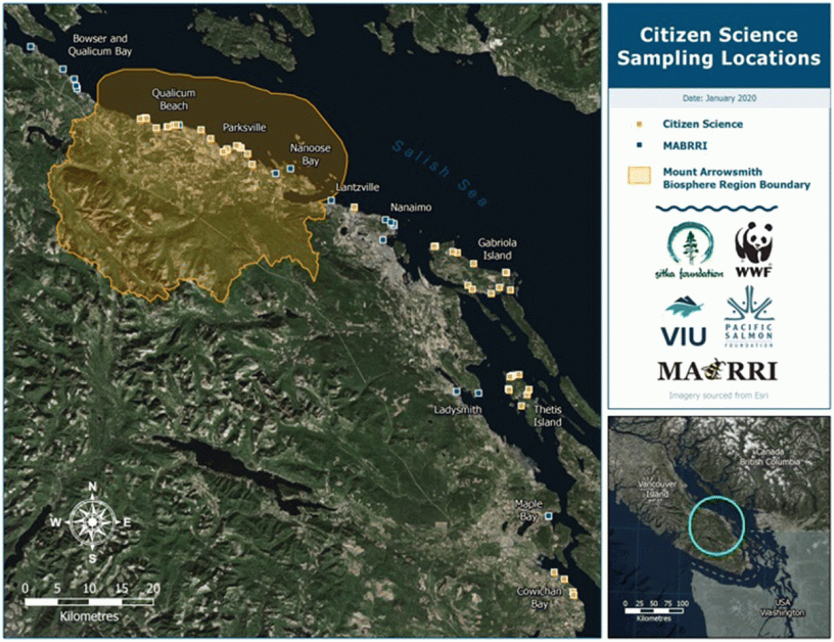
Fig. 1. Forage fish sample stations sampled by citizen scientists and Mount Arrowsmith Biosphere Region Research Institute within the 11 sample regions on Vancouver Island and the Gulf Islands (data sources: Homeland Infrastructure Foundation-Level Data (HIFLD) 2017; United States Census Bureau (USCB) 2018; Esri 2021; Ministry of Forests, Lands, Natural Resource Operations and Rural Development (MFLNRORD) 2021).
Site selection
There were three modes of site selection used for forage fish spawning surveys: (i) predictive mapping, (ii) local ecological knowledge, and (iii) on-the-ground site identification based on beach accessibility and characteristics.
Research assistants generated over 30 maps using Coastal and Ocean Resources’ predictive model (Cook 2018). Using ShoreZone mapping, the research assistants selected site characteristics favourable of both Pacific sand lance and surf smelt, including sediments that are either sand, pea gravel, or a mix of both and have overhanging vegetation. Once the predictive model was run, the areas along the coast that had the selected characteristics were highlighted. The field team visited all selected sections of the coastline that were publicly accessible from Cowichan Bay to Bowser to determine the accuracy of the predictive mapping as well as to set up sample stations where sites were deemed appropriate (refer to Supplementary Material, Fig. S1).
Local ecological knowledge is knowledge held by local people that have had a long-term relationship with their surrounding environment (Murray et al. 2011). By speaking with community members while frequenting the local beaches, other beaches in the area were identified as having forage fish intertidal spawning activity observed previously. Following the knowledge exchange, the research team had followed up on those beaches identified to determine if they had the preferable characteristics and whether a sample station should be established.
On-the-ground site identification involved finding all publicly accessible beach accesses and visiting the beaches to determine if they were suitable for a sample station. Marked beach accesses were found via Google Earth. Additionally, suitable sites had been found by driving along the coastline and identifying unmarked public beach access points.
Sample collection
Each visit to a sample station began with recording specific beach characteristics. MABRRI researchers followed the Qualified Environmental Professionals (QEP) methodology and datasheets (refer to Supplementary Material, Fig. S2) when sampling. To begin, the last high tide and second effective high tide were recorded. The last high tide would be the most recent high tide event that occurred prior to sampling, while the second effective high tide is a high tide that occurred up to 24 h before the last high tide and had a height that was of equal or greater value. Using tide tables from the Government of Canada’s website, recent high tide events were determined to identify the intertidal height that spawning forage fish could have reached. Tidal elevation was determined using a stadia rod and a clinometer to determine the height of the transect tape relative to chart datum. In Washington State, studies showed that the most ideal zone to sample for Pacific sand lance and surf smelt embryos is 2–3 m above the mean lower low water mark, which is 1.1 m for the Nanaimo Region (Moulton and Penttila 2006; Canadian Hydrographic Services 2016). Episodic events that occurred within one week prior to sample collection were identified and recorded. Studies have identified that storm events can disturb sediments, displacing them as a result of strong waves (Quinn et al. 2012). These data are collected to determine if the disturbance events negatively influence forage fish spawning activities.
Site attributes such as aspect, bearing, and beach slope were determined using a compass and clinometer during each site visit. Other site attributes such as fetch distance and exposure were determined through chart measurements only after the initial site visit. Within the sample area, the dominant sediment type was observed and recorded using a predetermined composition scale. The integrity of the backshore, referring to how impacted the beach is up to 30 m above the high-water mark, was recorded using a scale denoted in 25% increments. The width and length of suitable spawning area were calculated using a measuring tape and GPS, respectively. Lastly, the amount of shading that the sample area experiences, on a daily and seasonal average, was recorded using a scale that increases in 25% increments.
A 30 m transect tape was extended parallel to the water line at each designated sampling area. A 500 mL plastic container was used to scoop sediment along the transect tape to fill a 4 L plastic container. Sediment was collected biasedly, selectively sampling for suitable sediments from 2.5 m above and 2.5 m below the transect tape. Some beaches are subject to change because of their dynamic nature; therefore, some of the beach’s suitability can vary throughout the year or sometimes only small sections of the beach appear to be suitable. During site visits where the sediment was not suitable along the entire transect tape, sampling efforts were focused on only those areas that had suitable sediment. For this monitoring project, biased sampling was appropriate because the purpose is to identify beaches with forage fish embryos present, rather than assess egg density at our sampling locations. Many of our sampling beaches were also dynamic over the course of the year and the sediment size would drastically change anywhere from sand to cobble. As a result, not all sampling locations were able to be sampled each month throughout our monitoring project, rather they were only sampled when they consisted of the preferred sediment types (refer to Supplementary Material, Tables S1–S11).
Sample processing
Samples collected in the 4 L containers were sorted through a stack of sieves (Fred’s Gold Panning & Mining Supplies, Kelowna, BC, Canada) that are 4, 2, and 0.5 mm in size. Sediment samples that remained in the 0.5 mm sieve were processed via the vortex method, developed by WDFW (Dionne 2015).
The vortex method is a recirculating system where a pump powered by a 12 V marine battery draws up water from a 68 L tote into the blue bowl (Fred’s Gold Panning & Mining Supplies, Kelowna, BC, Canada) set on top of the tote. The water enters the conical bowl at an angle to create a circular flow. As the water fills the blue bowl, it begins to spill over the elevated opening at the centre of the bowl, washing through the 0.5 mm sieve that sits beneath the bowl, ultimately returning to the tote. The low-pressure system that results from the circular flow isolates the lighter sediments and organic material (e.g., fish embryos) from the sample. The heavier sediments remain at the base of the bowl, while all of the lighter sediments and organic material wash over the elevated opening in the centre and were collected on the 0.5 mm sieve that sits below the blue bowl. To aid the process, the sediments are agitated with a spatula to ensure that all lighter materials that were trapped under heavier materials are released and collected. Sediment and organic material that was collected on the 0.5 mm sieve underneath the bowl were collected into a sample jar to be analyzed for forage fish embryos. In between processing each of the samples, all of the equipment was washed to prevent cross-contamination.
Sample analysis
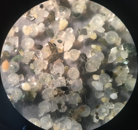
Samples were analyzed under a dissecting microscope at 20× magnification. Samples were examined by taking a spoonful of sediment and spreading it thinly across a petri dish. Identified forage fish embryos were photographed, collected into scintillation vials, and preserved with Stockard’s solution. Photographs of embryos were sent to WDFW for confirmation of species identification. The species and number of embryos were recorded for each sample.
Citizen science
Modifications were made from the QEP methods to accommodate citizen science involvement. These variations were to ensure simplicity and feasibility for the citizen scientists aiding in the collection of data. In addition, the modifications confirmed the sampling could be completed by anyone regardless of their field work experience or background. The alterations resulted in fewer materials required, allowing for greater expansion of the citizen science program as sampling kit costs were reduced.
Citizen scientists completed the sample collection and sample processing methods in the same manner as the QEP methodology. However, information such as tidal elevation, episodic events, and site attributes found on the QEP datasheet were not required to be collected by the citizen scientists; these characteristics were omitted from the citizen science datasheet (refer to Supplementary Material, Fig. S3). In addition, the length of spawning habitat required an over or under 100 m determination, eliminating the need for a GPS to measure length. Tidal elevation was recorded at as many sites as possible. However, citizen scientists were not provided with the necessary equipment to calculate tidal elevation and MABRRI did not calculate tidal elevation when visual conditions were limited.
MABRRI researchers generated site documents for each of the 11 regions along the eastern mid-Vancouver Island coastline, including one for each Gabriola Island and Thetis Island. Citizen scientists were provided with these documents to help with sampling efforts and data collection. During initial site visits, MABRRI documented beach characteristics and measurements that were outlined in these documents and are a reference guide for citizen scientists when classifying certain site characteristics. Moreover, the document provided directions, coordinates, and photographs to ensure citizen scientists were able to visit the established sites and record other necessary information.
Sampling efforts occurred monthly, where possible, based on citizen scientist capacity. Similarly, if beach sediment was deemed unsuitable (cobble and (or) boulder material) at the time of the site visit, sampling would not be completed that month. Citizen science groups were equipped with one vortex kit per region, which allowed samples to be processed upon collection. Processed samples were then provided to MABRRI for analysis.
In total, citizen science groups regularly sample 42 of the 56 beaches and 45 of the 66 beach stations. Therefore, MABRRI regularly sampled 14 of the 56 beaches and 21 of the 66 beach stations; this number increased during the times when citizen science capacity was lower (e.g., summer, holidays, etc.). Since citizen scientists conduct the bulk of the sampling efforts, numerous quality assurance and quality control (QA/QC) protocols have been developed and implemented in an effort to reduce error. First, citizen scientists are provided with sampling windows for their region. By following these windows to sample, MABRRI ensures that the volunteers are collecting samples at the best possible time because the windows supplied are when the ideal tidal elevation for sampling is exposed. All datasheets are reviewed upon submission to MABRRI; the researchers QA/QC all values recorded, certifying accurate data was documented. Additionally, MABRRI researchers analyzed all samples and any embryos detected are confirmed by an expert from WDFW via photos and emails. The MABRRI researchers host training sessions with each citizen science group every three to four months, to ensure that poor sampling habits have not formed or persist. MABRRI researchers input all data entry and it is reviewed by multiple parties prior to submission to the Strait of Georgia Data Centre (SGDC).
Permit
Fish embryos that were collected as part of this project was approved by and conducted under Fisheries and Oceans Canada (XR 346 2017; XR 322 2018; XR 249 2019) scientific collection permit, which includes all citizen scientist groups.
Preliminary results
Site selection
Of the 56 different beaches that were sampled, 29 of those sites were predicted by the predictive mapping to be suitable, four were identified by local ecological knowledge, and 23 were selected via on-the-ground site identification. Of the 29 sampled beaches that were predicted to have suitable forage fish spawning habitat, eight of the sites had embryos detected. Additionally, of the four beaches that were identified by local ecological knowledge, three of the beaches had embryos detected. Finally, of the 23 beaches selected by on-the-ground site identification, six had embryos detected.
Embryo detection
All forage fish embryos of interest found at our selected study sites during our monitoring project from 2017 to 2020 were Pacific sand lance (Fig. 2); no surf smelt embryos were detected. A complete summary of our egg findings, which includes the beaches that the embryos were found and their respective sampling date, is included in the Supplementary Material (Table S12). In total, 581 samples were collected between December 2017 and February 2020. The number of samples collected increased with the project’s progression (Fig. 3). However, summer months had fewer samples collected as a result of reduced sediment suitability and limited volunteer capacity.
Fig. 2.
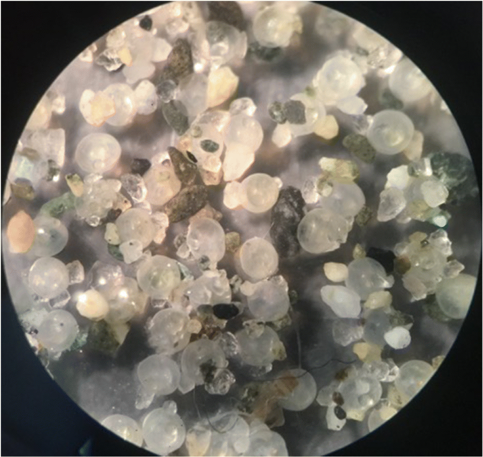
Fig. 2. Pacific sand lance embryos found at the Icarus Park Beach on 17 December 2019.
Fig. 3.
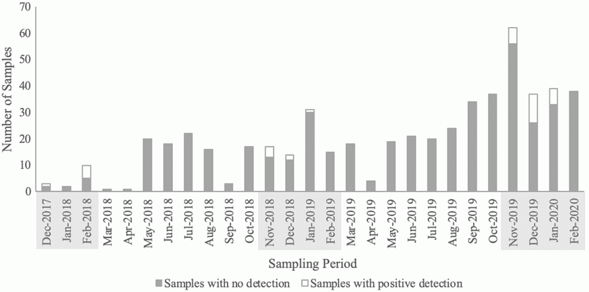
Fig. 3. Total number of samples collected with embryos detected (white) and nondetection (grey) throughout Mount Arrowsmith Biosphere Region Research Institute’s sampling period up until February 2020. The shaded month-year columns identify the spawning season of Pacific sand lance and when all embryo detection samples were found. All samples with embryo detection are Pacific sand lance.
There were 37 samples with Pacific sand lance embryos detected from 17 beaches (19 beach stations) (Fig. 4; Table 1). In the 2017–2018 Pacific sand lance spawning season (November to February), 15 samples were collected from 13 beaches (14 beach stations) with embryos found at four beaches (five beach stations); there was one beach in the Bowser and Qualicum Bay region, one beach in the Qualicum Beach region, and two beaches in the Parksville region. In 2018–2019 spawning season, 76 samples were collected from 27 beaches (27 beach stations). In total there were five beaches with Pacific sand lance embryos detected; there was one in Qualicum Beach, one in Parksville, one in Maple Bay, and two on Gabriola Island. In the 2019–2020 spawning season, 175 samples were collected from 40 beaches (47 beach stations). There were 13 beaches (14 beach stations) with sand lance embryos detected: one in Bowser and Qualicum Bay, one in Qualicum Beach, one in Parksville, one in Nanoose, one in Lantzville, three in Nanaimo, one in Maple Bay, and four on Gabriola Island. Preliminary analysis of the data collected shows that five of the 17 beaches have had Pacific sand lance embryos detected in two of the three spawning seasons that have been monitored (Table 1). In total, citizen scientists collected 16 of the 37 samples that had Pacific sand lance embryos detected, contributing to identifying eight of the 17 beaches that had spawning activity.
Fig. 4.
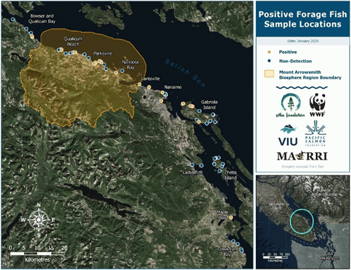
Fig. 4. Forage fish sample locations, including those with Pacific sand lance detected and nondetection sites between December 2017 and February 2020, in the mid-Vancouver Island region (data sources: HIFLD 2017; USCB 2018; Esri 2021; MFLNRORD 2021).
Fig. 5.
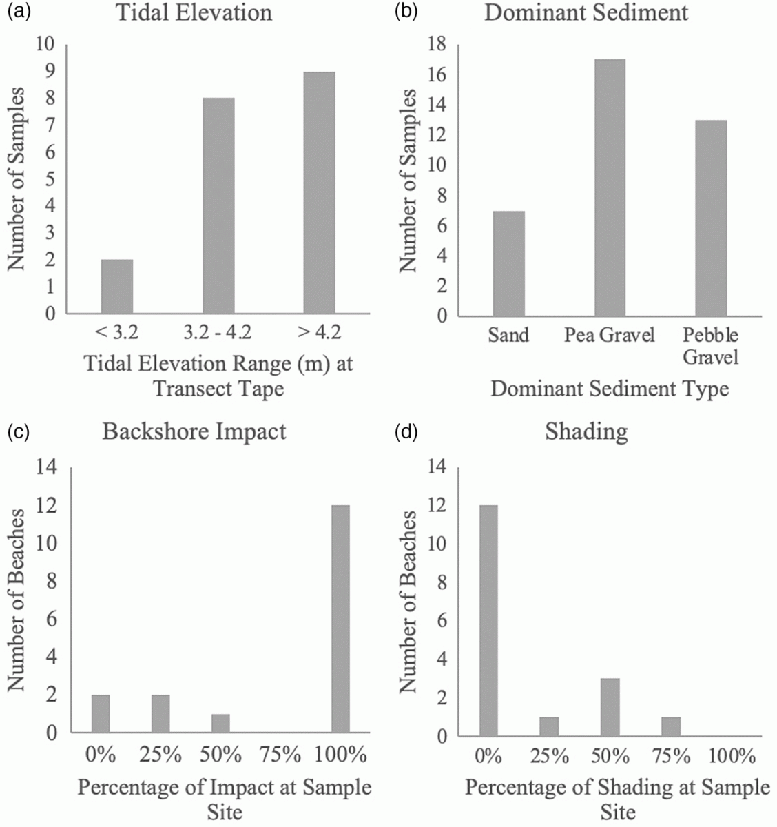
Fig. 5. Beach characteristics described for sites where Pacific sand lance embryos were detected. (a) Tidal elevation (m) was measured at the time of sediment collection and represents the height of the transect tape relative to chart datum; (b) dominant sediment considers the most prominent sediment type within the 5 m × 30 m sample area; (c) backshore impact represents how impacted the area, up to 30 m above the high water mark, was at the time of sample collection; and (d) shading represents the amount of the sample area that was shaded, considering a daily and seasonal average.
Table 1. Embryo detection throughout Pacific sand lance spawning seasons.
|
Geographic landmass |
Region |
Beach |
Beach station |
2017–2018 |
2018–2019 |
2019–2020 |
|
Vancouver Island |
Bowser and Qualicum Bay |
Sunny Beach |
1 |
D |
ND |
D |
|
Vancouver Island |
Qualicum Beach |
Little Qualicum Beach |
3 |
NS |
D |
ND |
|
Vancouver Island |
Qualicum Beach |
Judges Row |
2 |
NS |
NS |
D |
|
Vancouver Island |
Qualicum Beach |
Milner Garden |
1 |
D |
ND |
ND |
|
Vancouver Island |
Parksville |
McMillian Beach |
1 |
D |
D |
ND |
|
Vancouver Island |
Parksville |
Community Park Beach |
1 |
D |
NS |
ND |
|
Vancouver Island |
Parksville |
Community Park Beach |
2 |
D |
ND |
ND |
|
Vancouver Island |
Parksville |
San Pariel |
1 |
NS |
NS |
D |
|
Vancouver Island |
Parksville |
San Pariel |
4 |
NS |
NS |
D |
|
Vancouver Island |
Nanoose |
Northwest Bay Beach |
1 |
NS |
ND |
D |
|
Vancouver Island |
Lantzville |
Sebastian Beach |
1 |
NS |
ND |
D |
|
Vancouver Island |
Nanaimo |
Icarus Park Beach |
1 |
NS |
NS |
D |
|
Vancouver Island |
Nanaimo |
Morningside Beach |
1 |
NS |
ND |
D |
|
Vancouver Island |
Nanaimo |
Departure Bay Beach |
1 |
NS |
ND |
D |
|
Vancouver Island |
Maple Bay |
Maple Bay Beach |
1 |
NS |
D |
D |
|
Gabriola Island |
Gabriola Island |
Pilot Bay |
1 |
NS |
ND |
D |
|
Gabriola Island |
Gabriola Island |
Sandwell Beach |
1 |
NS |
D |
D |
|
Gabriola Island |
Gabriola Island |
Ru Bay |
1 |
NS |
ND |
D |
|
Gabriola Island |
Gabriola Island |
El Verano Beach |
1 |
NS |
D |
D |
Note
Vancouver Island locations are listed north to south. D, detection; ND, nondetection; NS, not sampled.
Site characteristics
Site characteristics were only analyzed for sites that had Pacific sand lance embryos detected. Tidal elevation (Fig. 5a) was >4.2 m, up to 5.64 m, for nine of the positive samples; 3.2–4.2 m for eight of the positive samples; and <3.2 m, no <3.1 m, for two of the positive samples. Tidal elevation was not calculated during every sample collection due to variation of sampling methods and accessibility. Tidal elevation was collected during 51% of the sampling events. Samples with embryos detected were dominantly comprised of pea gravel (18 sites), followed by pebble gravel (13 sites), and sand (seven sites) (Fig. 5b). Backshore integrity (Fig. 5c) varied amongst the 17 beaches: 12 beaches were identified as 100% impacted, one beach was 50% impacted, two beaches were 25% impacted, and two beaches were 0% impacted. Daily and seasonal averages of shading (Fig. 5d) also varied: 12 beaches were fully exposed (0% shading), one beach had 25% of the area shaded, three beaches were 50% shaded, one beach was 75% shaded, and zero beaches were 100% shaded.
The beach stations all varied with regards to their aspect, with no trend identified for preference of beach aspect from the samples collected (Table 2; refer to Supplementary Material, Fig. S4). All beaches that were sampled had an inclined slope, defined as being between 5° and 20°. All recorded slopes were between 5° and 11°. Some of the beaches had a slope that varied throughout the year as a result of wind and wave action; however, all variations were only 1°–2° and they remained inclined by definition. Beach slope was not determined during every sample collection as a result of the sampling methods that were used.
Table 2.
Table 2. Forage fish sample station beach aspects.
|
Beach aspect |
Number of beach stations |
|
North northwest |
2 |
|
North |
5 |
|
North northeast |
3 |
|
Northeast |
3 |
|
East northeast |
1 |
|
East |
2 |
Storm data were considered for each sample that was collected. Of the 37 positive samples that were collected between December 2017 and February 2020, only one of the samples experienced any storm events. The sample collected at Judges Row, sample station two, experienced three storms within a week prior to the sample date. The sample was collected on 17 January 2020, and the storm events occurred on 10 January 2020 (37 km/h), 12 January 2020 (59.5 km/h), and 15–16 January 2020 (38.6 km/h).
Discussion
Sampling results
All Pacific sand lance embryos found were detected within Washington State’s described spawning window, between November and mid-February. The majority of embryos were detected in November and December. For the first two spawning seasons that MABRRI monitored, 2017–2018 and 2018–2019, the majority of beaches with embryos detected were in the Parksville and Qualicum Beach regions, with only one in the Maple Bay region and two in the Gabriola Island region (Table 1). These results are indicative of where the sampling efforts were first undertaken. As the research team and citizen scientists were able to expand sampling efforts, both geographically and temporally (collecting a greater number of samples), there appeared to be a more even distribution of spawning sites along the Vancouver Island coastline from Qualicum Beach south to Maple Bay. In the 2019–2020 year, there were 14 beaches with embryos detected, with two more sites from the Gabriola Island region, two in Parksville, and another five between Nanaimo and Nanoose Bay. Although the MABRRI research team has not identified any surf smelt spawning beaches in the study area, Peninsula Streams Society and their volunteers in Victoria have recently identified surf smelt embryos (SGDC 2019a). Along the BC coastline, surf smelt spawning was thought to occur in the spring and summer months; however, surf smelt embryos were detected during January and March sampling events around the Saanich Peninsula on Vancouver Island (Therriault and Hay 2003; SGDC 2019a). Additionally, samples from January of 2012 found surf smelt spawning in the Victoria region (SGDC 2019b). Based on these data, the MABRRI research team will continue sampling beaches throughout the year to determine if there are surf smelt spawning in our sampling region and attempt to determine if they are winter, summer, or year-round spawners.
In total, there were 56 different beaches identified as potential forage fish spawning habitat between Cowichan Bay and Bowser on Vancouver Island, including sites on Gabriola Island and Thetis Island. Of the three site selection methods identified, including predictive mapping, local ecological knowledge, and on-the-ground site identification, predictive mapping identified the greatest number of beaches with suitable spawning habitat characteristics. Although it predicted the largest number of beaches that were sampled, it was not the most useful tool as it over-predicted potential spawning habitat in many areas and under-predicted it in others. Further, many of the areas that were identified as potentially suitable spawning habitat were large stretches of beaches that had a lot of variation; therefore, it was not the predictive mapping, but the on-the-ground observations that lead to the establishment of the beach stations.
Finally, considerable expanses of the coastline that were identified by the predictive mapping were not publicly accessible via the road or public beach accesses; therefore, many of those sites were not examined. Ultimately, the predictive mapping was a key starting tool to aid the research team in identifying potential regions to further investigate. Although local ecological knowledge identified the least number of beaches, it resulted in the greatest success rate, three of the four sites (75%) had embryos detected. Finally, on-the-ground site identification was essential to identifying potential forage fish spawning habitat, as well as ground truthing the predictive mapping.
Of the positive sites that tidal elevation was recorded, most of the sampling areas (89%) were at a tidal elevation greater than or equal to 3.1 m above chart datum. These results suggest that the upper intertidal zone is primarily used for Pacific sand lance spawning activities. Many beach characteristics were collected during sampling efforts, including beach aspect and beach slope. No trends were identified from the data that were collected to indicate if these beach characteristics influenced Pacific sand lance spawning.
All of the sediment samples taken from the positive sites were determined to be predominantly sandy substrates (0.0625–2.0 mm), pea gravel (2.0–4.0 mm), or pebble gravel (4.0–64.0 mm) (Fig. 5b). These results support other findings that Pacific sand lance spawn on beaches containing sand and gravel substrates (Hiss 1985; Penttila 2007; Robinson et al. 2013; Selleck et al. 2015). The size of these substrates and preference for spawning habitat suggest that sediment smaller than this would not be suitable due to less oxygenation and a compacted substrate (Quinn 1999). Because of the size of Pacific sand lance and surf smelt embryos (<1 mm), larger sediment such as cobble gravel and boulders would most likely not adhere to the embryos.
The percentage of shading on the beaches that had Pacific sand lance embryos detected in their samples, appear to be intrinsically linked to the integrity of the backshore. Figures 5c and 5d are nearly mirrored; the greater the backshore was impacted, the less shading that was available. Coastlines have always been an attractive place for anthropogenic development (Nordstrom 2003). As the backshore is developed for human activity, it is typical that vegetation is removed. As a result, beaches lose the shading that the natural vegetation once provided them (Nordstrom 2003). Studies have indicated that the overhanging vegetation along the coastline is beneficial to those forage fish that are depositing their embryos in the upper intertidal zone, especially summer spawning surf smelt (Penttila 2001). Shading in the intertidal zone results in fewer and less extreme temperature fluctuations, especially in the summertime when the tide is out. When the forage fish embryos are deposited on the beach, they are vulnerable to the elements; if they are exposed to the hot sun, they are more vulnerable to desiccation (Penttila 2001). Pacific sand lance embryos that were found in this study were less likely influenced by the amount of shading because they were spawned in the wintertime when conditions were cooler and wetter, which would reduce the likelihood of desiccation.
Forage fish monitoring guidance document
Due to the limited, inconsistent monitoring of forage fish beach spawning sites in BC, the establishment of a long-term monitoring project resulted in the development of a Guidance Document for Forage Fish Beach Spawning Surveys in BC (wwf.ca/wp-content/uploads/2020/07/Guidance-Document-Forage-Fish-Beach-Spawning-Surveys-in-British-Columbia-1.pdf). This document provides resources and guidance for environmental consultants, academics, conservation groups, and citizen scientists on how to establish a monitoring program for forage fish spawning surveys in the intertidal regions of BC’s Salish Sea. However, since Pacific sand lance and surf smelt are nearshore coastal fish ranging throughout the coastal waters of BC, this document can be used to aid in the expansion of forage fish beach spawning surveys beyond the BC Salish Sea. Overall, this document can be used to help certify that the long-term monitoring data collected on suitable forage fish spawning beaches is consistent amongst organizations, groups, and (or) citizen scientists sampling.
Citizen science initiative
The inclusion of volunteer community members to aid in data collection, known as citizen science, is beneficial in many ways. This method works to keep the community informed, contribute to and facilitate research, encourage important discussion of current events, and further knowledge of environmental issues. Ultimately, these can have an overarching effect on the community as a whole, changing their knowledge, attitudes, and behaviours towards an issue at hand. Additionally, continued participation and inclusion in the program helps to spread awareness, driving the community to work together towards a common goal. Through continuous citizen science involvement, more data can be collected which are then submitted to an open-access database. These data help to fill the existing data gaps and can eventually help to identify long-term trends. Without their help, there would be significantly less data collected.
The development of a simplified methodology allows more people to participate while still ensuring the necessary information is collected. By taking over entire sampling regions and contributing to knowledge sharing, citizen scientists have aided in the geographical expansion of the program (Fig. 1). Their involvement allows researchers to focus their efforts on sampling new areas and recruiting more citizen scientists, demonstrating a positive feedback cycle. For example, citizen science groups on the southern Gulf Islands have ensured that areas that are not easily accessible to researchers on a continuous basis are being sampled regularly.
Management implications and open-access database
In Canada, the federal government has jurisdictional control over the seacoast and fisheries, with some ocean-related responsibilities and activities being carried out by the provincial and territorial governments of Canada (DFO 2009). DFO is responsible for enacting the Fisheries Act, which has a mandate to protect all fish and their habitat from death and destructive alteration of their habitat. DFO reviews project applications for proposed work below the high-water mark; approved project activities contain provisions designed to avoid, minimize, and mitigate against the death of fish and harmful alterations to their habitats. Some activities (e.g., placing fill or structures above the high-water mark), which might have the potential to harm forage fish and their spawning habitat, do not require project reviews or authorizations from DFO. The province of BC owns and controls the foreshore/intertidal zone; thus, it has a significant role in ocean-related responsibilities (DFO 2009). Under the BC Land Act, the minister can lease or license the right to use the foreshore/intertidal zone including beach spawning habitat, while local governments have the authority to regulate shoreline modifications through planning, zoning bylaws, and permitting processes (Carlson 2018).
A federal regulatory measure designed to protect all fish and their habitat are timing windows. These windows are designed to protect fish, including their eggs, juveniles, spawning adults, and (or) the organisms upon which they feed by only allowing project activities to occur in and around the water within these windows (DFO 2014). Presently, the marine/estuarine timing windows around the BC Salish Sea, including the MABR, range from either 1 November to 15 February or 1 December to 15 February (DFO 2014). Our positive embryo detections for Pacific sand lance within the MABR, along with other regions in the BC Salish Sea have been detected within the prescribed timing window that was designed to protect fish, including their eggs from project activities, such as marina expansions and marine outfalls.
Thus, this regulatory measure is unlikely achieving the desired protection of Pacific sand lance and their habitat during their spawning window (November to mid-February). As longer-term temporal data surrounding the positive embryo sites of Pacific sand lance and surf smelt are collected and submitted to an open-access database, further knowledge around their spawning windows could further support that certain regulatory provisions are inadequately protecting these ecologically important fish species in BC.
Data submitted into an open-access database results in the dissemination of information surrounding the forage fish beach surveys in the BC Salish Sea, including the beaches surveyed, locations of positive embryo detections, and temporal data. With access to this data, conservation organizations can advocate for improvements to the protection of fish and their habitat (i.e., regulatory modifications) and (or) restoration activities. Additionally, it can be used as an aid to municipal and regional planners regarding the type of development (e.g., seawalls or riparian removals) that should or should not occur along the shoreline adjacent to beaches. Similarly, citizen scientists may use the information provided in the database as a tool when advocating for changes within their community or to simply inform and bring awareness to the environmental sensitivities and importance of timing windows. Our data are contributed to Forage Fish Monitoring in the Salish Sea open-access database within the (SGDC 2019c).
The SGDC allows other researchers and citizen scientists to contribute their forage fish data sets into a centralized site. The contribution of other forage fish beach spawning data from a wider range of geographic regions (e.g., Sunshine Coast) will help to further fill in the data gaps surrounding spawning seasonality and habitat for Pacific sand lance and surf smelt in BC. Therefore, having access to this longer-term data and understanding potential trends can be an important tool in identifying ecological changes due to human activities and climate change. In addition, longer-term data will highlight the most crucial sites that need protection, on both a local and provincial scale, as well as sites that require habitat restoration.
Acknowledgements
We wish to acknowledge the help and guidance provided by Phillip Dionne, from the Washington Department of Fish and Wildlife. Phillip provided the MABRRI team with initial training in the sampling and vortex methods and has continued to provide advice when we have sought it. Additionally, Phillip continues to provide in-kind support with species and embryo (species) confirmation. We would also like to extend a special thank you to Pam Thuringer, who has also provided continuous support to the MABRRI team throughout this project. Pam also aided in the initial training of the MABRRI team, and still provides guidance and assistance with embryo (species) confirmation. We would like to thank Ariel Verhoeks, MABRRI’s GIS Specialist, who was able to pull together all the visuals required for this paper and all other forage fish materials and handouts used throughout the project. We are extremely grateful for the continued funding support from the Pacific Salmon Foundation, the Sitka Foundation, and WWF—Canada throughout this project. Without our funders we would not be able to complete this important work ourselves, or train and equip our citizen scientists with the materials they need to help. Further, we would like to thank the Nature’s Trust of British Columbia and Vancouver Island University for providing seed funding to this project to get it up and running. Finally, we would like to express our immense gratitude to the citizen science groups that have been working with us over the past two years. Without the time that they volunteer to this project, we would not be able to cover the geographic range that we have been able to cover in this short period of time. So, thank you to the following groups: Gabriola Island Shorekeepers, Thetis Island Nature Conservancy, Mid-Vancouver Island Habitat Enhancement Society, Qualicum Beach StreamKeepers, Dover Bay Secondary School Eco-Club, and the Cowichan Bay group.
References
Anthony JA, Roby DD, and Turco KR. 2000. Lipid content and energy density of forage fishes from the northern Gulf of Alaska. Journal of Experimental Marine Biology and Ecology, 248(1): 53–78.
Boldt J, Therriault T, Cleary J, Schweigert J, Flostrand L, Hay D, et al. 2012. Forage fish management in British Columbia, Canada. In Conservation and ecology of marine forage fishes—Proceedings of a Research Symposium, September 2012. Edited by T Liedtke, C Gibson, D Lowry, and D Fagergren [online]: Available from eopugetsound.org/sites/default/files/features/resources/ConservationAndEcoMarineForageFishes2012.pdf.
Canadian Hydrographic Services. 2016. Nanaimo Harbour and/et Departure Bay.
Carlson D. 2018. Infographic: jurisdiction in coastal BC [online]: Available from wcel.org/publication/infographic-jurisdiction-coastal-bc.
Cook S. 2018. Using ShoreZone to model suitable forage fish spawning habitat in the Gulf Islands [online]: Available from wwf.ca/wp-content/uploads/2020/07/Appendix-A-Using-ShoreZone-to-Model-Suitable-Forage-Fish-Spawning-Habitat-in-the-Gulf-Islands-1.pdf.
Cury P, Bakun A, Crawford RJM, Jarre A, Quiñones RA, Shannon LJ, et al. 2000. Small pelagics in upwelling systems: patterns of interaction and structural changes in “wasp-waist” ecosystems. ICES Journal of Marine Science, 57: 603–618.
Dionne P. 2015. Vortex method for separation of forage fish eggs from beach sediment: addendum to the 2006 revision of field manual for sampling forage fish spawn in intertidal shore regions [online]: Available from wdfw.wa.gov/sites/default/files/publications/02022/wdfw02022.pdf.
Engelhard GH, Peck MA, Rindorf A, Smout SC, van Deurs M, Raab K, et al. 2014. Forage fish, their fisheries, and their predators: who drives whom? ICES Journal of Marine Science, 71(1): 90–104.
Esri. 2021. World Imagery (firefly) [basemap; online]: Available from arcgis.com/home/item.html?id=a66bfb7dd3b14228bf7ba42b138fe2ea.
Essington TE, Moriarty PE, Froehlich HE, Hodgson EE, Koehn LE, Oken KL, et al. 2015. Fishing amplifies forage fish population collapses. Proceedings of the National Academy of Sciences of the United States of America, 112(21): 6648–6652.
Fisheries and Oceans Canada (DFO). 2002. Surf smelt. Report No. B6-09. Canadian Science Advisory Secretariat, Nanaimo, British Columbia [online]: Available from waves-vagues.dfo-mpo.gc.ca/Library/345799.pdf.
Fisheries and Oceans Canada (DFO). 2009. The role of the provincial and territorial governments in the oceans sector. Report No. DFO/2008-1494. Oceans Directorate, Ottawa, Ontario [online]: Available from waves-vagues.dfo-mpo.gc.ca/Library/337906.pdf.
Fisheries and Oceans Canada (DFO). 2014. British Columbia marine/estuarine timing windows for the protection of fish and fish habitat—south coast and lower Fraser areas [online]: Available from dfo-mpo.gc.ca/pnw-ppe/timing-periodes/bc-s-eng.html.
Harvey CJ, Bartz KK, Davies J, Francis TB, Good TP, Guerry AD, et al. 2010. A mass-balance model for evaluating food web structure and community-scale indicators in the central basin of Puget Sound. Report No. NMFS-NWFSC-106. U.S. Department of Commerce, NOAA National Marine Fisheries Service, Seattle, Washington [online]: Available from researchgate.net/publication/316169970_A_mass-balance_model_for_evaluating_food_web_structure_and_community-scale_indicators_in_the_central_basin_of_Puget_Sound.
Haynes TB, and Robinson CLK. 2011. Re-use of shallow sediment patches by Pacific sand lance (Ammodytes hexapterus) in Barkley Sound, British Columbia, Canada. Environmental Biology of Fishes, 92(1): 1–12.
Hiss JM. 1985. Summary of life history of Pacific sand lance (Ammodytes hexapterus) and its distribution in relation to Protection Island National Wildlife Refuge. U.S. Fish and Wildlife Service, Olympia, Washington. 5 p.
Homeland Infrastructure Foundation-Level Data (HIFLD). 2017. Canada and United States International boundary [shapefile; online]: Available from hifld-geoplatform.opendata.arcgis.com/datasets/canada-and-us-border.
Lee CG, and Levings CD. 2007. The effects of temperature and desiccation on surf smelt (Hypomesus pretiosus) embryo development and hatching success: preliminary field and laboratory observations. Northwest Science, 81(2): 166–171.
Levings CD, and Jamieson G. 2001. Marine and estuarine riparian habitats and their role in coastal ecosystems, Pacific region. Canadian Science Advisory Secretariat Research Document 2001/109. Fisheries and Oceans Canada (DFO), British Columbia [online]: Available from metchosinmarine.ca/gf/wp-content/uploads/2013/09/MarineRiparianHabitatsLevingsJamieson2001.pdf.
Lowry D. 2012. Forage fish management in Washington. In Conservation and ecology of marine forage fishes—Proceedings of a Research Symposium, September 2012. Edited by T Liedtke, C Gibson, D Lowry, and D Fagergren [online]: Available from eopugetsound.org/sites/default/files/features/resources/ConservationAndEcoMarineForageFishes2012.pdf.
Meyer RM. 1997. Forage fishes in marine ecosystems: introduction to the symposium. In Forage fishes in marine ecosystems. Proceedings of the International Symposium on the Role of Forage Fishes in Marine Ecosystems. Alaska Sea Grant College Program Report No. 97-01. University of Alaska Fairbanks. 809 p.
Middaugh DP, Hemmer MJ, and Penttila DE. 1987. Embryo ecology of the Pacific surf smelt, Hypomesus pretiosus (Pisces: Osmeridae). Pacific Science, 41(1–4): 44–53.
Ministry of Forests, Lands, Natural Resource Operations and Rural Development (MFLNRORD). 2021. Freshwater atlas watersheds [dataset; online]: Available from catalogue.data.gov.bc.ca/dataset/3ee497c4-57d7-47f8-b030-2e0c03f8462a.
Moulton LL, and Penttila DE. 2006. San Juan county forage fish assessment project field manual for sampling forage fish spawn in intertidal shore regions [online]: Available from wdfw.wa.gov/sites/default/files/publications/01209/wdfw01209.pdf.
Murray C, Wieckowski K, Hurlburt D, Soto C, and Johnnie K. 2011. Incorporation of traditional and local ecological knowledge and values in fisheries management [online]: Available from www-deslibris-ca.ezproxy.viu.ca/ID/228809.
Nordstrom KF. 2003. Beaches and dunes of developed coasts. Cambridge University Press.
Orr JW, Wildes S, Kai Y, Raring N, Nakabo T, Katugin O, et al. 2015. Systematics of North Pacific sand lances of the genus Ammodytes based on molecular and morphological evidence, with the description of a new species from Japan. Fishery Bulletin, 113: 129–156.
Ostrand WD, Gotthardt TA, Howlin S, and Robards MD. 2005. Habitat selection models for Pacific sand lance (Ammodytes hexapterus) in Prince Williams Sound, Alaska. Northwest Naturalist, 86(3): 131–143.
Penttila DE. 2001. Effects of shading upland vegetation on egg survival for summer-spawning surf smelt on upper intertidal beaches in Puget Sound [online]: Available from salishsearestoration.org/images/7/7b/Penttila_2001_shading_and_surf_smelt_egg_survival.pdf.
Penttila DE. 2007. Marine forage fishes in Puget Sound. Report No. 2007-03. Puget Sound Nearshore Partnership, U.S. Army Corps of Engineers, Seattle, Washington.
Quinn T. 1999. Habitat characteristics of an intertidal aggregation of Pacific sandlance (Ammodytes hexapterus) at a North Puget Sound beach in Washington. Northwest Science, 73(1): 44–49.
Quinn T, Krueger K, Pierce K, Penttila D, Perry K, Hicks T, et al. 2012. Patterns of surf smelt, Hypomesus pretiosus, intertidal spawning habitat use in Puget Sound, Washington State. Estuaries and Coasts, 35(5): 1214–1228.
Reed MG, and Massie MMM. 2013. Embracing ecological learning and social learning: UNESCO biosphere reserves as exemplars of changing conservation practices. Conservation and Society, 11(4): 391–405.
Robards MD, and Piatt JF. 1999. Biology of the genus Ammodytes, the sand lances. In Sand lance: a review of biology and predator relations and annotated bibliography (USDA Forest Service Research Paper PNW-RP-521). Edited by MD Robards, MF Willson, RH Armstrong, and JF Piatt. USDA Forest Service, Pacific Northwest Research Station, Portland, Oregon. pp. 1–16.
Robards MD, Willson MF, Armstrong RH, and Piatt JF (Editors). 1999. Sand lance: a review of biology and predator relations and annotated bibliography (USDA Forest Service Research Paper PNW-RP-521). USDA Forest Service, Pacific Northwest Research Station, Portland, Oregon.
Robinson C. 2019. State of Pacific sand lance research in British Columbia [PowerPoint slides; online]: Available from frafs.ca/sites/default/files2/6a.%20Robinson_PSL%20SRKW%20Prey%20Availability%20TWG.pdf.
Robinson CLK, Hrynyk D, Barrie JV, and Schweigert J. 2013. Identifying subtidal burying habitat of Pacific sand lance (Ammodytes hexapterus) in the Strait of Georgia, British Columbia, Canada. Progress in Oceanography, 115: 119–128.
Selleck JR, Gibson CF, Shull S, and Gaydos JK. 2015. Nearshore distribution of Pacific sand lance (Ammodytes personatus) in the inland waters of Washington State. Northwest Naturalist, 96(3): 185–195.
Siple MC, Essington TE, and Plagányi ÉE. 2019. Forage fish fisheries management requires a tailored approach to balance trade-offs. Fish and Fisheries, 20(1): 110–124.
Sisson NB, and Baker MR. 2017. Feeding ecology of Pacific sand lance in the San Juan Archipelago. Marine and Coastal Fisheries: Dynamics, Management, and Ecosystem Science, 9(1): 612–625.
Strait of Georgia Data Centre (SGDC). 2019a. A secure Data Centre for Information on Marine Ecosystems of the Strait of Georgia. World Wide Web electronic publication [online]: Available from soggy.zoology.ubc.ca:8080/geonetwork/srv/eng/catalog.search#/metadata/eafe951e-b0fb-437c-9e5e-a1fee6dd81ea.
Strait of Georgia Data Centre (SGDC). 2019b. A secure Data Centre for Information on Marine Ecosystems of the Strait of Georgia. World Wide Web electronic publication [online]: Available from soggy.zoology.ubc.ca:8080/geonetwork/srv/eng/catalog.search;jsessionid=node0hofgqpvpfz79ylytla5u1ivn3369.node0#/metadata/f85f8c8b-f31b-4ee4-9c8e-5f6d716ee003.
Strait of Georgia Data Centre (SGDC). 2019c. A secure Data Centre for Information on Marine Ecosystems of the Strait of Georgia. World Wide Web electronic publication [online]: Available from soggy.zoology.ubc.ca:8080/geonetwork/srv/eng/catalog.search#/metadata/c198358b-6a06-4496-8eb2-8e94474a3592.
Strait of Georgia Data Centre (SGDC). 2020. Ramona de Graaf [online]: Available from sogdatacentre.ca/people/researchers/ramona-de-graaf/.
Therriault TW, and Hay DE. 2003. Surf smelt (Hypomesus pretiosus) in Burrard Inlet, British Columbia: evidence of recreational overharvesting? In Georgia Basin/Puget Sound Research Conference, Vancouver, British Columbia. Department of Fisheries and Oceans, Pacific Biological Station. 6 p.
Therriault TW, Hay DE, and Schweigert JF. 2009. Biological overview and trends in pelagic forage fish abundance in the Salish Sea (Strait of Georgia, British Columbia). Marine Ornithology, 37: 3–8.
Thuringer P. 2004. Documenting Pacific sand lance (Ammodytes hexapterus) spawning habitat in Baynes Sound and the potential interactions with intertidal shellfish aquaculture. Master’s thesis, University of Victoria, Victoria, British Columbia.
United States Census Bureau (USCB). 2018. States [shapefile; online]: Available from census.gov/geographies/mapping-files/time-series/geo/carto-boundary-file.html.
Van Pelt TI, Piatt JF, Lance BK, and Robards DD. 1997. Proximate composition and energy density of some North Pacific forage fishes. Comparative Biochemistry and Physiology Part A: Physiology, 118(4): 1393–1398.